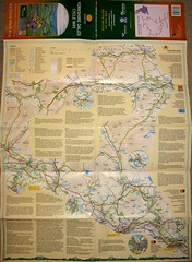

It winds across 170 miles of some of Britain’s most spectacular countryside. The new Way of the Roses Cycle Route has just opened and I’m itching to get into the saddle to conquer it.
The route passes through places that are deeply embedded in my life – Ripon and York, places where I have lived and now live. The roads outlined in yellow on the map are both familiar and new. I have probably traversed the whole route at one time or another – but never strung together in one long trek from the Irish Sea to the North Sea. Altogether it looks to be better than the C2C which in my experience loses it’s charm as it crosses some of the more industrialised parts of county Durham and on to the sea. The Roses in contrast skirts the Yorkshire Wolds and heads towards Bridlington in its closing miles.
I have another reason to face the challenge of the ride. I am involved in setting up a new charity to provide homes for homeless people in York. It’s a daunting and challenging project in itself, but we need to some seed funding until it becomes self sustaining. At a meeting to form the charitable trust this week I raised the prospect of riding the Way of the Roses, and the challenge was immediately picked up by my relatively new friend Ed Hambleton. Ed and I separately had the vision to provide housing and support for homeless people and were brought together when, in the same week, we contacted Green Pastures Housing for some help and guidance. That was at the end of last year. Now we are working together with other Christians in York to breath life into the vision.
So expect another invitation to visit a giving website and donate to our cause.
One thing puzzles me about the Way of the Roses route. Next to the village of Clapham just off the A65 there’s a puzzling warning. “Steep hill, poor surface, pedestrians, children, dogs and dark tunnels” Just what awaits us there?
 This is the definitive and only route map for the Coast to Coast ride and it’s out of print. I’ve exhausted all outlets expect eBay where someone is selling it for £99.00 and another is on auction and already up to £31.00. That’s for a map that only costs £7.95. So if you’ve done the ride and don’t need it any more – or would lend it to me for my charity ride that starts on Wednesday – I would really appreciate it.